Science explained · Earth & Environment
How Does Lightning Form?
How does an insulating gas become a branching conductor across kilometers of sky?
Explore the sections in this article
A thunderstorm is a particle-sorting machine
The useful action occurs in the cloud's mixed-phase region, where liquid droplets remain supercooled below 0 °C while ice crystals and graupel coexist. Graupel is a soft ice pellet produced as supercooled droplets freeze onto a falling ice particle. Strong updrafts keep these ingredients colliding while gravity and airflow give them different trajectories.
Collisions can transfer a small amount of charge. In a commonly observed temperature and liquid-water range, small ice crystals leave collisions positively charged while graupel becomes negative. The light crystals are carried upward more readily; heavier graupel remains suspended lower or falls. Repetition separates enormous numbers of small charges into broad regions.
This is called noninductive charging because it does not require the colliding particles to begin with a charge induced by an external field. Inductive processes, droplet breakup, melting and other effects can also matter. Charge sign can reverse with temperature, liquid-water content and particle growth conditions. The tidy textbook tripole—positive top, negative middle, smaller positive pocket below—is a useful common pattern, not a universal cloud wiring diagram.
The updraft supplies organization, not electrical charge
Warm moist air rising into a thunderstorm cools, condenses and releases latent heat. That energy helps maintain buoyancy and a strong updraft. The airflow does not manufacture electrons. It moves differently charged hydrometeors apart faster than collisions and conduction can completely neutralize them.
Gravity supplies the other half of the sorting. A small ice crystal may be swept into the anvil while graupel has a much larger fall speed. Turbulence mixes particles and makes the charge structure lumpy, folded and time-dependent. Downdrafts can carry charged precipitation into new regions.
This distinction matters because “positive charge rises” is not a law of weather. Particles rise or fall according to forces on their mass and shape; their charge is a consequence of microphysical interactions. Under different conditions, inverted storm polarity can occur. So be wary of any diagram that appears to show positive charge floating upward of its own accord. Buoyancy belongs to the particle, never to the charge it carries.
Charge separation creates an electric field
Separated charge produces an electric field: a force per unit charge. As the separation and charge density grow, the field becomes stronger. The ground also responds electrostatically. Negative charge in a storm's lower region repels mobile electrons in the ground, leaving the surface below relatively positive; a positive anvil can produce the opposite response farther away.
It is tempting to multiply the conventional breakdown field of dry air near sea level—roughly 3 million volts per meter—by a kilometer and declare that a storm needs 3 billion volts. That is the wrong model. Cloud air is not a smooth parallel-plate laboratory gap. Pressure changes with altitude; water and ice distort local fields; streamers create space charge; energetic particles and pre-existing ionization may contribute; and breakdown develops in short, nonuniform regions.
Balloon measurements often find large-scale fields below the simple conventional threshold. That mismatch is not evidence that lightning violates electromagnetism. It tells researchers that initiation depends on local structure and dynamic discharge physics rather than one cloud-wide voltage number.
The first breakdown remains a frontier
Lightning mapping arrays locate bursts of very-high-frequency radio emission from small segments of a developing flash. Interferometers resolve even faster motion. These instruments have revealed processes called fast positive and fast negative breakdown, in which streamer systems can advance rapidly through strong-field regions before familiar leaders develop.
Rison and colleagues used radio observations of narrow bipolar events to show fast positive breakdown at the beginning of some flashes. Later work found related activity across a wider range of lightning initiation. These results changed the opening frames of the story, but they did not produce one universal ignition recipe.
Possible ingredients include locally enhanced fields near hydrometeors, networks of streamers and energetic-electron avalanches influenced by cosmic-ray secondaries. Different observed events may begin through related but nonidentical paths. “Scientists do not know anything before the leader” is outdated; “the initiation mystery is solved” is equally premature.
A leader builds a conducting road
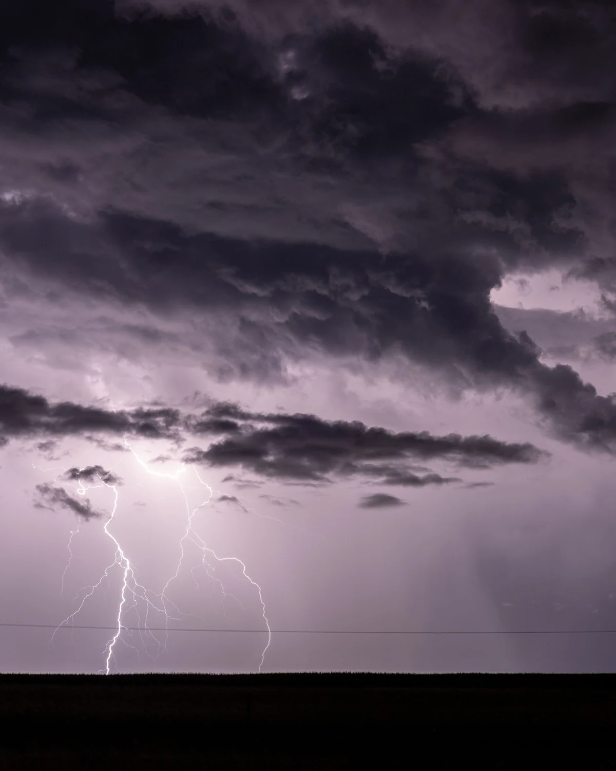
Once a hot, ionized channel can sustain current and extend, it is called a leader. Leaders do not move like a solid wire thrown across the sky. Their tips produce intense fields that create new ionization ahead; the channel lengthens through branching, heating and charge transport.
Negative leaders commonly advance in discrete steps, pausing and branching. Positive leaders tend to propagate more continuously, though real behavior is complex. A flash can remain entirely within a cloud, connect different clouds, reach the ground, or grow upward from a tall structure. Most lightning is not the familiar single cloud-to-ground fork.
NWS material estimates that most cloud-to-ground flashes begin with a downward negative leader and a smaller fraction with a downward positive leader. Those percentages describe observed categories, not a rule for an individual storm. Positive cloud-to-ground flashes can involve different charge regions and may carry long continuing currents.
The ground does not wait passively
As a negative stepped leader approaches, its electric field intensifies at sharp or elevated objects. Upward positive streamers may rise from trees, buildings, poles, terrain—and people. Several may begin, but typically one makes the successful connection.
The connection point need not be the tallest object in the broad landscape. Leader geometry, local field enhancement, distance and competing streamers all matter. Metal also does not “attract” lightning in the folk sense. Conductive structures influence current paths and can be engineered to intercept and carry a strike safely, but a metal object does not summon a storm discharge from arbitrary distance.
When leader and streamer connect, a continuous conducting route links a cloud charge reservoir with the ground. The route may be only centimeters across, yet it can extend kilometers and branch through a much larger volume of sky.
The return stroke is bright because the channel changes fast
After connection, current rises sharply and a return-stroke wave propagates upward along the previously formed channel. Negative charge moves toward ground, while the luminous change appears to travel from the connection point upward. This is why saying “the bolt comes down” captures the leader but misses the most visible propagation.
The channel heats air to temperatures on the order of 30,000 K; NWS expresses an upper comparison near 50,000 °F. The hot gas emits intense light and expands, producing thunder. Temperature, diameter and current vary along a flash and through time. “Five times hotter than the Sun's surface” is a scale comparison, not a complete thermodynamic description.
High-speed NWS examples show leader-to-return-stroke development occurring in fractions of a second—about 1/133 second in one recorded flash and 1/50 second in another. Those are measured examples, not universal timers.
One flash can contain several strokes
The first return stroke may not end the event. If the channel remains partly conducting and the cloud still holds charge, a faster dart leader can descend through the old route and another return stroke follows. Repetition makes the light appear to flicker.
Branches that did not connect may also brighten when current redistributes. Continuing current can persist after a stroke and is especially important for heating and fire ignition. A camera exposure can merge multiple strokes into one branching image, while a high-speed camera separates them.
This vocabulary prevents a common counting error. A flash is the larger electrical event; a stroke is one high-current pulse within some cloud-to-ground flashes. Detection networks may report flashes, strokes, groups or events depending on the instrument and product.
Lightning can travel without touching the ground
Intracloud lightning connects oppositely charged regions within one storm and is the most common broad class. Cloud-to-cloud and cloud-to-air discharges also occur. Upward lightning can initiate from tall towers or wind turbines, especially in strong fields or winter storms.
The luminous channel can extend horizontally through an anvil before a branch reaches ground far from the heaviest rain. This defeats the dangerous idea that dry ground means safety. The active electrical volume is larger than the rain shaft visible to one observer.
Sprites and other transient luminous events occur high above some thunderstorms, driven by electrical changes associated with powerful lightning. They are related atmospheric discharges, not giant conventional bolts climbing into space.

How researchers see an event too fast and dangerous to approach
Electric-field mills track changes at the surface. Instrumented balloons sample fields and particles inside storms. Lightning mapping arrays time radio arrivals across several stations to reconstruct three-dimensional source locations. Optical cameras reveal leaders and return strokes; spectrometers estimate plasma conditions; satellite instruments such as the Geostationary Lightning Mapper observe optical pulses over broad regions.
At specialized facilities, researchers launch a small rocket trailing wire under controlled storm conditions to trigger lightning. This does not reproduce every natural initiation process, but it creates a known target for synchronized current, field, optical, X-ray and acoustic instruments.
Every method sees a different proxy. A radio source is not automatically the hottest channel; an optical pulse can saturate a camera; a ground network has detection thresholds; a satellite views cloud-top light scattered through cloud. Reliable reconstruction combines instruments rather than treating one map as the flash itself.
A quantitative thought experiment: why local fields matter
Take a simplified spherical ice particle with radius 1 millimeter carrying 1 picocoulomb of charge. Ignoring nearby particles and the conductive wet surface, the electric field at its surface would be approximately
E = kQ/r² = (8.99 × 10⁹)(1 × 10⁻¹²)/(1 × 10⁻³)² ≈ 9,000 V/m.
That is far below conventional air breakdown. Increase charge to 100 picocoulombs and shrink the relevant tip curvature, however, and local fields rise dramatically. Many particles, space charge and existing streamers reshape the field again.
The calculation is deliberately incomplete; real graupel is irregular, nearby charges matter and charge leaks. Its value is conceptual: a storm cannot be reduced to one average field. Breakdown seeks concentrated geometry and evolves by changing the very field that drives it.
A lightning map is a filtered account
The same flash can look different in three data products. A ground radio-frequency network may locate return strokes and estimate current polarity. A Lightning Mapping Array follows thousands of VHF sources from leader activity through the cloud. A satellite optical sensor groups brief illuminated pixels after cloud scattering has spread the light.
Their “flash counts” need not match because algorithms decide which events belong together across space and time. Detection efficiency changes with distance, network geometry, cloud depth, day/night background and signal strength. A map with no symbol at one location does not certify that no discharge occurred there.
This matters beyond instrumentation. Researchers compare lightning with rainfall, wildfire ignition and storm intensity, but the definition of a flash is part of the analysis. A rise in detected events can reflect a real storm change, a new sensor or a revised clustering algorithm. The physical discharge precedes every product; the product is evidence sampled through a particular threshold.
For public safety, those distinctions reinforce rather than weaken the official rule. Consumer maps can support awareness, but their latency and detection limits do not replace thunder, local alerts or a venue's established shelter plan.
Lightning safety is not a prediction exercise
No cloud shape, hair sensation, phone photograph or homemade field detector lets a reader predict the next strike point. NWS guidance is simpler because the hazard is broader than visual intuition: if thunder is heard, the observer is within potential striking distance and should move to a substantial enclosed building or a hard-topped metal vehicle.
Open shelters, tents and isolated trees are not safe lightning shelters. Rain ending does not mean electrical activity has ended; official guidance advises waiting 30 minutes after the last thunder before resuming outdoor activity. Local warnings and venue plans take priority over an explainer.
The flash-to-thunder delay can estimate distance to the portion of channel producing the first sound, but it is not permission to remain outside and calculate. Lightning can occur from another part of the storm before the counted thunder arrives.
What the honest answer includes
Storm-scale charge separation is strongly linked to collisions among graupel, small ice and supercooled water in a vigorous mixed-phase region. Airflow and gravity sort the particles. Localized breakdown develops; leaders construct conducting channels; connection and return stroke produce the brightest cloud-to-ground event.
The first discharge physics and the microphysical charge transferred in every collision remain conditional on a storm's state. That uncertainty does not weaken the mechanism. It identifies the boundary between a reliable sequence and an active frontier.
The next time a bolt appears, the important action is already behind it: ice has collided, charge has been transported, air has been ionized and a branching road has reached its connection. The flash is the road lighting up.
Frequently asked questions
Is lightning made by clouds rubbing together?
No. Charge separation occurs largely through collisions among individual ice particles, graupel and supercooled droplets within turbulent airflow. Whole clouds do not rub like balloons.
Does lightning travel up or down?
Both descriptions can apply to different stages. In a common negative cloud-to-ground flash, a stepped leader develops downward, an upward streamer connects, and the bright return-stroke wave propagates upward along the channel.
Is all lightning cloud-to-ground?
No. Much lightning stays within a cloud. Discharges can also occur between clouds, from cloud toward air, or upward from tall structures.
Why does lightning branch?
The intense field at a leader tip creates ionization ahead along multiple possible routes. Local charge, particle geometry and prior channels make the field uneven, so several tips can develop while only some continue.
Can lightning strike where it is not raining?
Yes. Channels can extend through an anvil and reach ground away from the visible rain shaft. Hearing thunder is the practical safety boundary.
Does metal attract lightning?
Metal conducts current well but does not pull lightning from arbitrary distance. Height, shape, position and developing leader geometry influence connection. Engineered protection provides a preferred, bonded path to ground.
Can lightning strike the same place twice?
Yes. Tall or exposed structures may be struck repeatedly, and one flash can reuse a channel for multiple strokes.
Have scientists solved lightning initiation?
They have measured fast breakdown and mapped early radio sources in great detail, but no single initiation pathway yet explains every natural flash.
Sources & further reading
This explainer was prepared through desk research using the sources below; established findings are distinguished from open questions in the text. See our editorial methodology.
- National Weather Service, Thunderstorm Electrification — mixed-phase charging zone, ice/graupel collisions, charge sorting and common storm charge structure.
- NWS, Types of Flashes; Initiation of Leaders; Making Connection With the Ground; Return Stroke — official sequence and terminology for a common negative cloud-to-ground flash.
- NWS, Slow Motion Video of Lightning Flashes — measured example timings and visible leader/return-stroke development.
- NWS, Lightning Safety — thunder as an immediate shelter trigger and official outdoor boundary.
- Saunders, “Charge Separation Mechanisms in Clouds,” Space Science Reviews 137 (2008) — review of noninductive and competing thunderstorm charging processes.
- Dwyer & Uman, “The Physics of Lightning,” Physics Reports 534 (2014) — fields, leaders, energetic particles, plasma and measurement limits.
- Rison et al., “Observations of narrow bipolar events reveal how lightning is initiated in thunderstorms,” Nature Communications 7 (2016) — primary radio evidence for fast positive breakdown during initiation.
- Stock et al., “Fast positive breakdown in lightning,” Journal of Geophysical Research: Atmospheres 122 (2017) — interferometric development and broader early-breakdown context.
- Rakov & Uman, Lightning: Physics and Effects (2003) — leader, stroke, channel and flash framework.
Spotted an error? We correct verified mistakes promptly — email contact@flashscience.org.
Continue exploring